
The Radar, acronym for Radio Detecting And Ranging, was born at first for military purposes during the first World War. During its first application for military defence, around 1940, it was discovered that this sensor was also able to detect objects or targets different from aircraft or ships, such as hydrometeors (rain, snow, hail). This finding marked the beginning of systematic studies for the application of the Radar for meteorological purposes, with further applications in operational areas and for Civil Protection purposes. The observation of an atmospheric volume by the Radar is part of remote sensing activities, implying a distance between the observer and the object of the study. The meteorological radar emits an electromagnetic wave, in the microwave spectrum, transmitted by an antenna in the free atmosphere. The wave hits the hydrometeors encountered along its path and its energy is partly absorbed, partly reflected in all directions by those particles. A small part of this wave is backscattered directly to the Radar and subsequently analyzed. The Radar is therefore emitting a signal having a certain energy – about 106 W – and receiving a signal, called “echo“, having a several orders of magnitude lower energy – about 10-3 W. Radar receiver measures the variation in power between the transmitted wave and the returning echo, that is a fraction of that energy transported in principle by the electromagnetic signal: this fraction of energy is called reflectivity, indicated with Z , and is measured in mm6/m3. Given that in reality it can cover a wide range of values, from very weak signals to very strong signals, it may be convenient to express it in dBZ, by means of the logarithmic decibel scale.
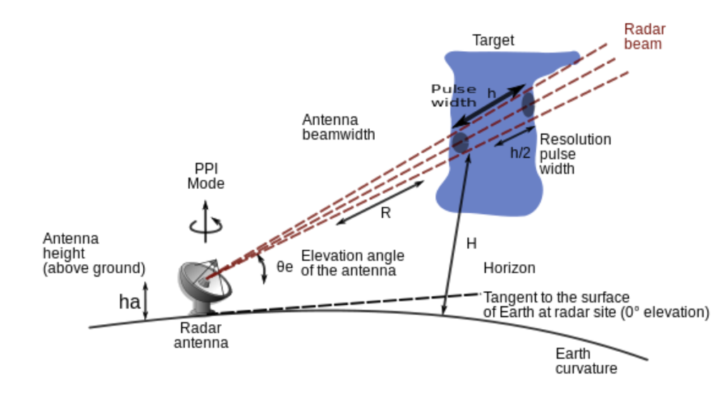
Reflectivity is related to the number of particles, hydrometeors, per unit of volume and to the sixth power of their diameter (Z~D6). It is a measure of how much power has been back scattered (backscatter) by each single hydrometeor (rain, snow, hail) and depends on the size, shape and composition of the hydrometeors analyzed: therefore large raindrops, but also hail, spread back c more energy and the Radar receiver measures high reflectivity values. On the other hand, snow has a lower reflectivity (5 <Z (dBZ) <30). To have a correct measure of reflectivity, it is essential to have a correct calibration of the Radar receiver first, and then of the Radar equation. A possible way to calibrate it is via the comparison with data coming from a disdrometer (Drop Size Distribution meter), an instrument that through a laser simultaneously detects the size and rate of fall of the hydrometeors. The radar equation relates the power of the signal transmitted by the Radar (known), with the backscattered one (measured), in order to calculate the reflectivity. It is precisely the accuracy in the measurement of the return signal power that allows to calculate a reliable value of Z, which can subsequently be related to the intensity of precipitation R (expressed in mm/h). Z-R are in fact linked by an equation from which the intensity of the precipitation R (mm/h) can be derived. The choice of a suitable set of parameters allows for a more accurate estimation of the precipitation, that can then be compared with measured punctual values of rain intensity from the rain gauges on the ground. By accurately estimating the intensity of precipitation, it is possible to subsequently obtain the cumulative rainfall over a given area or territory. Furthermore, the time that the transmitted signal takes to go back after being retro-diffused from the intercepted destinations allows to estimate the distance at which the hydrometeors are located. Thanks to its characteristics, the Radar represents one of the fundamental remote sensing sensors for Civil Protection monitoring activities, to mitigate the hydraulic and hydrogeological risk following adverse weather conditions.
The high spatial and temporal resolution of the data depends on the scanning strategy used to monitor a volume of sky in a given precipitative and territorial context; it allows for a more representative data than the punctual one deriving from the rain gauge. Also in the meteorological field there are different types of Radar, which differ one from each other not only for the hardware and software components, but above all for the physical properties of the electromagnetic signal they use: S band, C band, X band, band K and W band are the names of meteorological type Radars that use their own frequency band and wavelength depending on the required purpose. the most commonly used sensors for monitoring and warning activities, such as Civil Protection purposes, are those in band C and band X, which are also very different from each other.
In addition to the characterization of the meteorological radar just described, it must be emphasized that there are also Doppler and/or polarimetric radar, the use of which gives further information on the hydrometeors analyzed. Through the Doppler Radar it is possible to know the radial velocity of a particle V(m/s) by determining its frequency variation and to understand if it is approaching or moving away from the site where the Radar is located. The polarimetric functionality allows for additional qualitative information on the hydrometeors that single polarization radars do not allow to have. With regard to this, it should be emphasized that some of the meteorological radars existing today are single polarization and therefore transmit and receive the electromagnetic signal with a single polarization, the horizontal one. The polarimetric characteristic allows instead to send and receive electromagnetic waves both with respect to their horizontal and vertical polarization, the return signal thus provides a measure of the vertical and horizontal dimension of the hydrometeor, allowing to estimate its phase, shape and intensity. Differential reflectivity, ZDR (dB), for example, is a typical quantity of polarimetric radar and is a ratio of the power returned with horizontal and vertical polarization from the return signal: it is a good indicator of the shape of the hydrometeors (oblate, drop of rain, spherical, hailstone, or snow crystals), as well as its phase (liquid or solid) and intensity, as well as identifying echoes of non-meteorological destinations. Among the advantages of a polarimetric radar there is an improved accuracy in the estimation of the amount of precipitation and also the ability to distinguish between very intense rain, which has high values of Z (reflectivity) and ZDR (differential reflectivity) and hail, which also has high Z values, but low ZDR.

For a good monitoring activity of a specific territory it is necessary to consider the geomorphological characteristics of the territory and to consider when they can create limitations for the Radar, as for the case of obstacles to the signal created by elevations, but also the distance. In a national context it is essential to have a network of sensors, mainly C-band and Doppler-type, distributed throughout the territory to monitor it, so that the signal can freely analyze large atmospheric volumes even at a distance and thus create a national composite. In certain regional contexts, the X-band radar is also used which, unlike the C-band Radar which analyzes the hydrometeors even at distances of about 200km, monitors the atmospheric dome over a smaller space ranging from 90km to 30/40km for operational use. If the C-band Radars are more powerful in the range of the signal and in the scanning of the atmosphere at significant distances from the emission source, the X-band Radars are able to better read what happens in the atmosphere especially at a distance between 30 and 40 km, giving a further qualitative and quantitative element of the data.

In addition to the monitoring function, the information deriving from a meteorological radar is also useful for hydrological applications, such as the estimation of the amount of precipitation falling on a hydrographic basin, the intensity of the meteorological phenomenon on a restricted area and the possible implications in terms of surface runoff etc., aspects that the single rain gauge is not able to detect. Furthermore, the rainfall data of the Radar can be used in turn as input data of a hydrological model, as in the INADEF project. Last but not least, the Radar data can be used as an input data for a meteorological model, even at high resolution, which allows for forecasting and Nowcasting.