
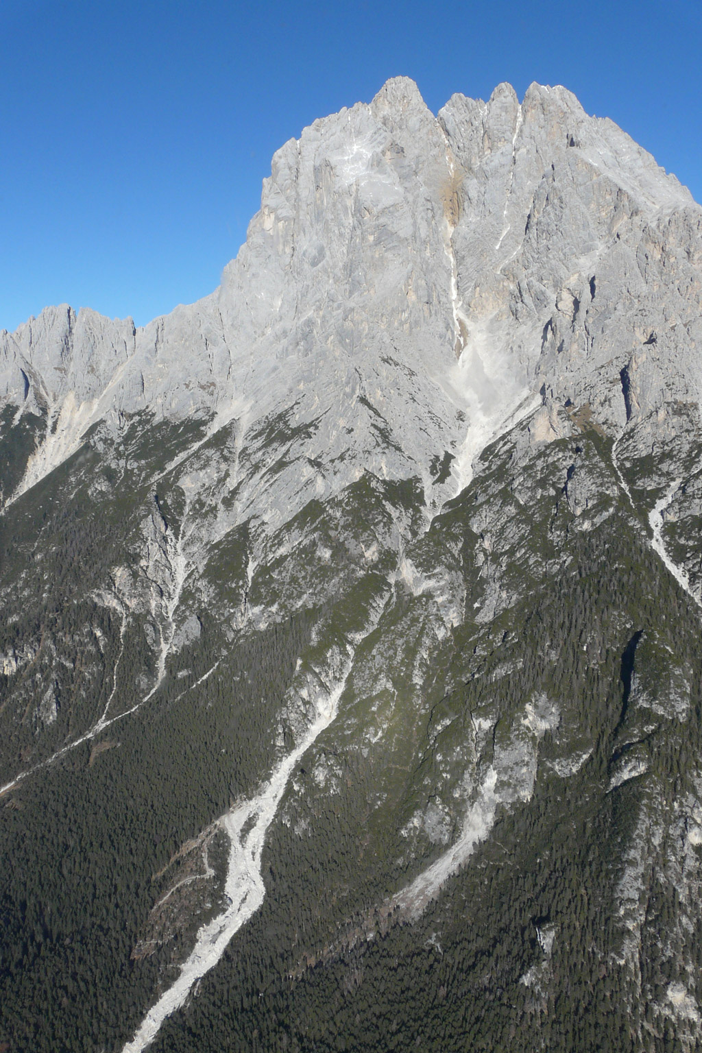
In the upper part, the basin is formed by rocky walls in main dolomite, which convey the flows on the rocky slopes of the Vallon dell’Antelao between 2000 and 2500 m a.s.l. Debris flows generally occur in summer and early autumn and are triggered by intense summer storms of short duration (10-20 minutes) which rapidly transform, along the rocky walls, into high-energy water currents; the latter have the ability to mobilize large quantities of sediment, triggering the debris flows. Below these powerful sediment sources, the channel joins a deep and narrow rocky gorge up to an altitude of 1600 m a.s.l. Between 1600 m a.s.l. and 1400 m a.s.l. the rio Rudan flows on deep Quaternary deposits that progressively excavates, in a section with alternating excavation and deposit. The dolomites and the conglomerate mass rests on layers of San Cassiano, dating back to the lower Carnian and consisting of marl and tuff, strongly altered and stratified, decidedly more impermeable than limestone rocks and conglomerates. The Rudan valley incision finds the layers of San Cassiano at 1400 m a.s.l., and the flow above this point is ephemeral.
Below the layers of San Cassiano the Rudan flows from 900 m a.s.l. down on the layers of Wengen (Upper Ladinian), composed of dense calcareous-marly-tufaceous stratification, with a morphology of bottom jumps and cascades densely embedded in the gorge, very similar to that described in the San Cassiano section. Downstream of the debris flow breaker dam and the inhabited area of Peaio, the Rudan stream does not form a fan, but flows in a valley dug into alluvial deposits and then reaches the Boite river on the limestones and conglomerates of the “Livinallongo del Ladinico Inferiore” formations.
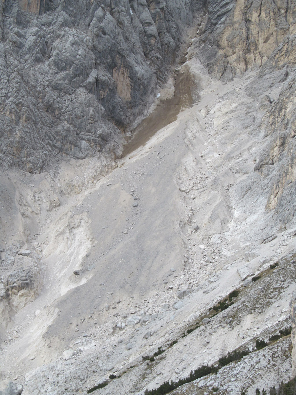
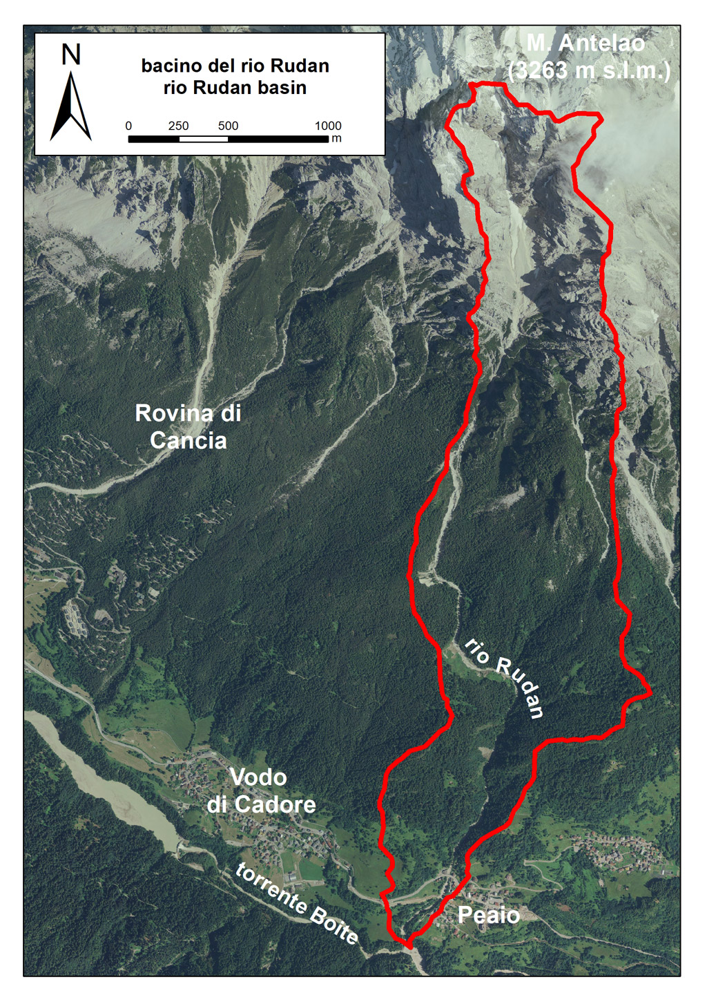
The rio Rudan basin and the Mount Antelao (on the left side – source: ARPAV) and detail of the debris flow triggering area in the Vallon dell’Antelao (on the right side – source: Comune di Vodo di Cadore)
.
There are numerous chronicles that report damage suffered to the settlements below Mount Antelao as a result of the Rudan debris flow phenomena, highlighting the remarkable activity of this stream. Most of the historical information, reported below, has been obtained from documents archive kindly made available by the Municipality of Vodo di Cadore.
The historical information of the historicale events related to Rudan is summarized in a synthetic way in the following table. They show a progressive increase in the frequency of events of considerable intensity over the last thirty years.
N | Date | Note |
1 | September 1882 | Considerable damages by destroying some mills that insisted on its banks and the sawmill that was located at the confluence with the Boite stream |
2 | September 1951 | Great alluvial phenomenon: some plants carried by the current leaned against the bridge of the National Road causing the arrest of a huge amount of material. The gravel and the other material covered the bridge for more than a meter |
3 | September 1983 | The first flood wave caused the almost total obstruction of the bridge over the N.R. n. 51 by depositing the debris transported in the upstream section of the collector. The flood event was so intense that it destroyed the concrete bridge built in 1952 on the “Strada Regia” |
4 | 19.07.1987 | The prolonged and intense rainfalls of the previous days caused the transport of enormous quantities of debris, in a very short time, along the Rudan. About 10000 m3 of material reached the confluence with the Boite river |
5 | 02.07.1994 | Flood characterized by a solid transport of large boulders only |
6 | 07.08.1996 | Debris flow with over-flooding of the riverbed at Peaio. The flow, after having overflowed on the right bank, obstructed the section under the bridge of the cycle path, causing it to rise and float. The bridge remained anchored to the guides on the shutters |
7 | 01.09.1998 | Several and substantial deposits of gravel as well as widespread erosion of the banks |
8 | 05.09.1998 | Accumulation of alluvial material in the riverbed of the Rudan stream at Peaio |
9 | 06-07.09.1998 | Several debris flows that caused huge accumulations of material near the village of Peaio. The flow overflowed upstream of the bridge over the National Road n. 51 depositing accumulations of sediment on the square of the “Antichità” shop on the right bank. Upstream of the Bailey bridge the flow overflowed onto the right bank |
10 | 12.09.1998 | Debris flow that caused accentuated and widespread erosive phenomena as well as the destabilization of two large areas (landslides) |
11 | 05.08.1999 | Considerable amount of debris that was deposited close to the bridge on the N.R. n. 51 creating danger of overflow |
12 | 20.09.1999 | Large debris flow with flooding in many points. The deposit endangered the viability of the National Road and caused the deposit of a significant amount of debris on the square next to the “Antichità” shop on the hydrographic right. Further downstream, the flood current completely removed the weir downstream of the Bailey bridge |
13 | 04.08.2015 | Debris flow with a total volume of approximately 25000 65000 m3, total duration 5-7 minutes. Damage to the dam, completely filled with material. Complete removal of the bridge of the cycle path and considerable under-excavation of the bank walls downstream of it |
14 | 06.08.2018 | Fluid debris flow triggered by a very localized storm in the Vallon dell’Antelao. Total volume equal to 40000 m3. Complete filling of the storage basin (removed volume equal to 10-12000 m3). Significant damage to a construction site in the riverbed near the Boite river |
15 | 29.08.2020 | Debris flow caused by the combination of significant cumulated rain and intense storm. Complete filling of the storage basin (total volume removed equal to about 17000 16000 m3) |
16 | 15-16.12.2020 | Repeated mudflow events caused by an extensive surface landslide on the left bank at an altitude of 1150 m a.s.l. (approximately), which caused the obstruction of the Rio Rudan. Liquefaction of the land of the landslide area produced by the heavy rains that fell 10 days earlier and by the melting snow. Considerable number of trees transported downstream and still present on the landslide and along the main riverbed. Total volume equal to about 5000 m3 (15/12) + 15000 m3 (16/12) |
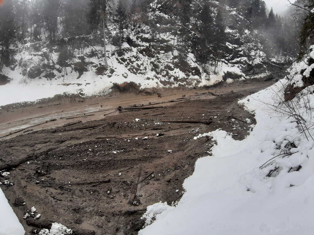
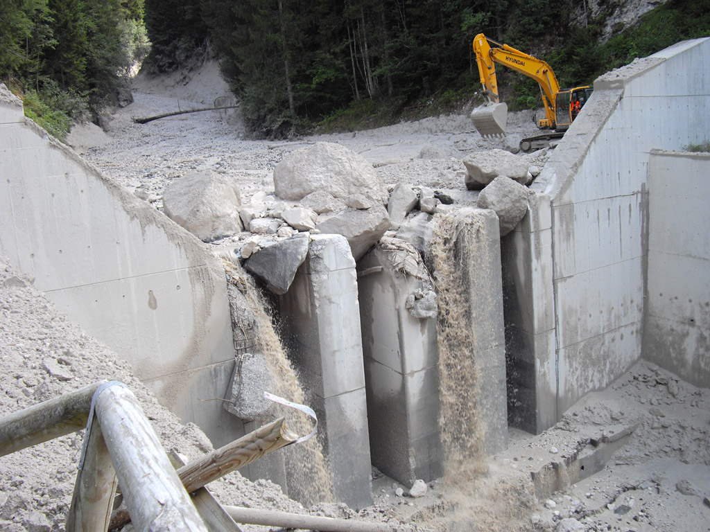
The dam damaged after the event of 04.08.2015 (ARPAV photo of 05.08.2015) and the storage basin after the event of 15-16.12.2020 (ARPAV photo of 16.12.2020)
The elements at risk are placed between an altitude of 950 m a.s.l. and the closing section: the bridge of the National Road n. 51 “d’Alemagna”, a municipal bridge of the Pieve di Cadore-Cortina d’Ampezzo cycle path and an inadequate drainage channel were critical sections for the disposal of debris flows with the risk of flooding and involvement of part of the settlement of Peaio.
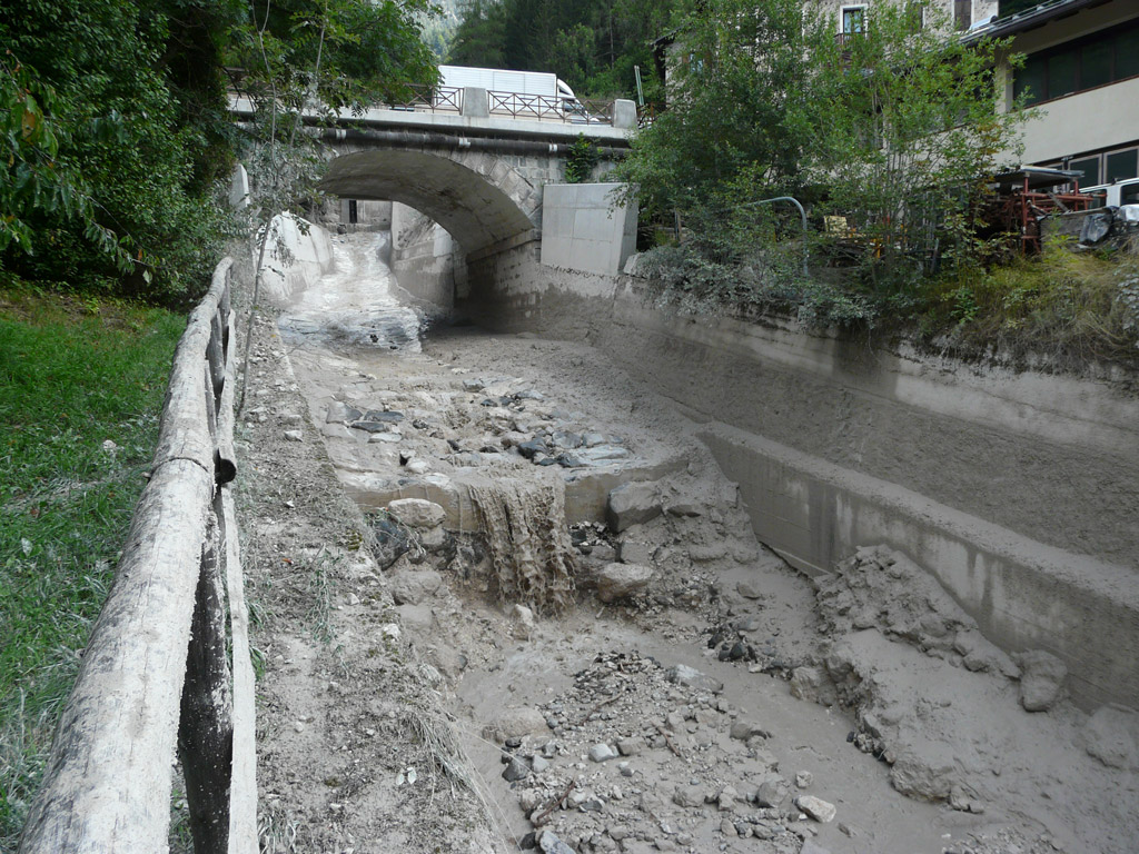
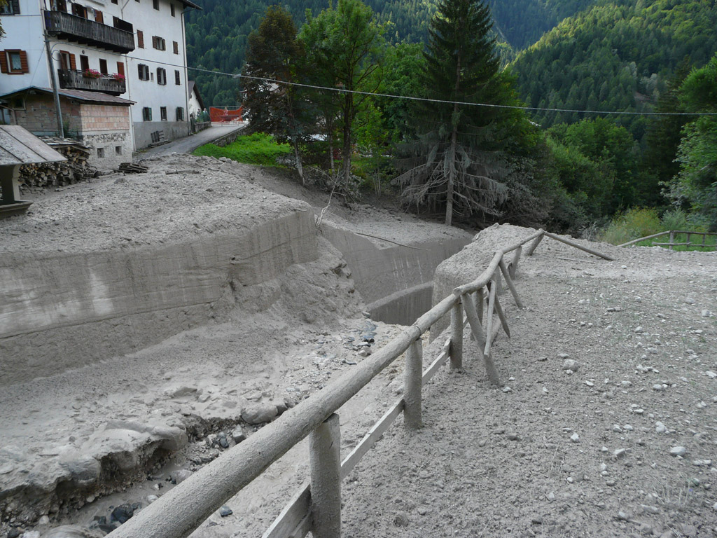
The Rio Rudan reach that crosses the settlement of Peaio: on the left just downstream of the bridge on the N.R. n. 51 “d’Alemagna”; on the right near the bridge of the cycle path removed by the event of 04.08.2015 (ARPAV photo of 05.08.2015)
At an altitude of 1580 m a.s.l. the channel flows at a point of possible overflow in a curve to the left; this point was then rectified with an intervention, creating a cliff with big boulders at the exit of the gorge in order to avoid avulsion phenomena (exit from the channel).
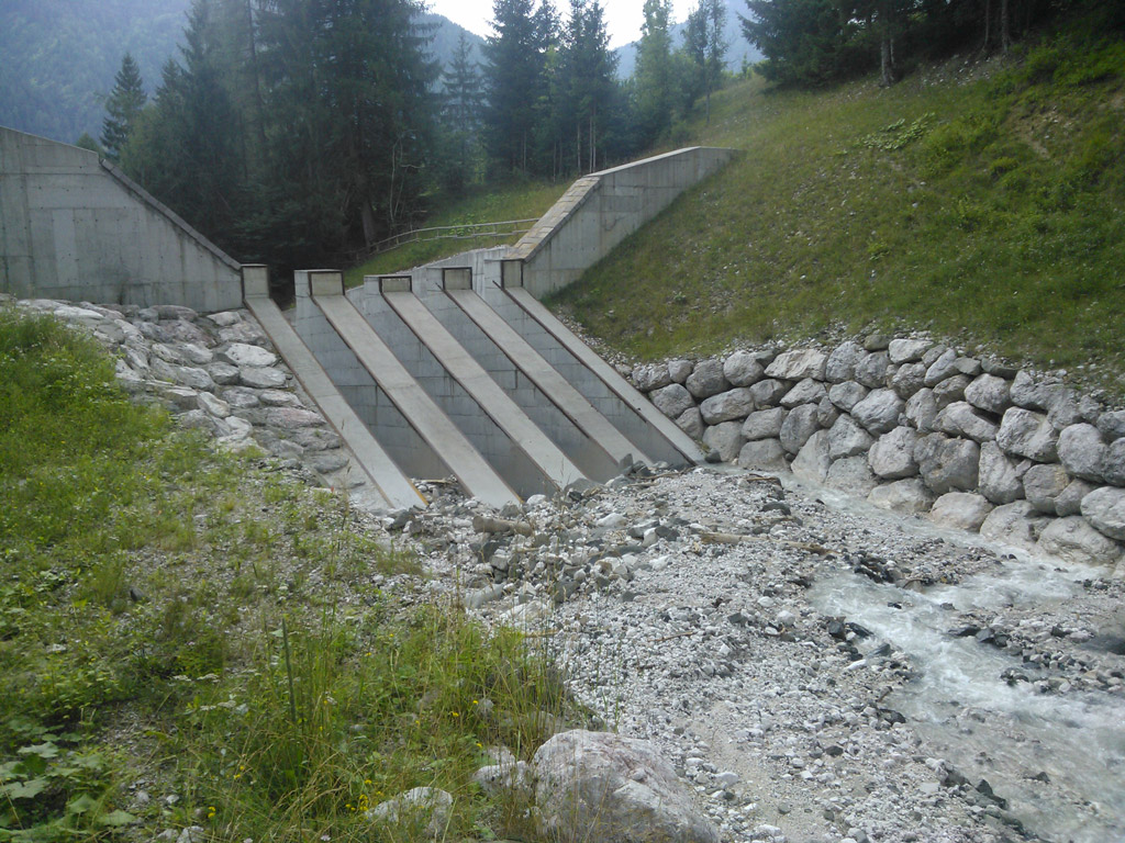
In 2011, the Veneto Region constructed a debris flow beaker dam with fixed vertical filters spaced 1.3 m and 1.3 m wide, with double trapezoidal water tank with a minimum height of 7.2 m and width 11.1 m. The crest is 19.1 m wide and 11.3 m high. The storage basin upstream of the work is estimated to have a capacity of 15000 m3, and the goal of the work is to laminate the debris flow peak and transform the flow into hyperconcentrated or bedload transport, so that it can flow under the bridge of the National Road without depositing in the artificial channel.
Several interventions of renovation and re-profiling of the channel downstream of the dam (paving and consolidation of the side walls) have been carried out over the years and are still ongoing.
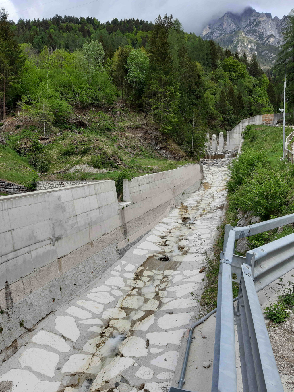
The debris flow breaker dam seen from upstream (left) and the section of the culvert between the dam and the bridge of the N.R. n. 51 “d’Alemagna” (photo by ARPAV)
In 2019, the Veneto Region built and tested the first portion of the monitoring and alarm system (designed by ARPAV) of the Rio Rudan debris flow. The system consists of two distinct phases: 1) monitoring and 2) diffusion of the alarm signal to the end users. It has been structured for monitoring two distinct phases related to the debris flow:
- monitoring of intense rainfall, capable of triggering the phenomenon of instability;
- monitoring of the triggered debris flow.
In order to structure an alarm system with sensor redundancy criteria, for minimizing the possibility of any missed alarms, the aforementioned sensors are located in 2 stations positioned at different places along the debris flow channel:
- “Rudan Antelao” station: located at an altitude of about 2140 m a.s.l. and consists of 2 rain gauges and a full HD day & night video camera;
- “Rudan Briglia” station: located around the dam at an altitude of 905 m a.s.l. as well as in the settlement of Peaio and along the communication routes. It consists of 7 trip wires along the stream and a full HD day & night video camera. Also related to this station are a lighting system equipped with 3 LED headlights, data collection software, alarm signal processing and system management, as well as traffic lights, information signs and the diffusion system of the alarm signal (sirens, flashing lights and massive messaging dispatch system).
Already in the design phase, pre-alarm rainfall thresholds and level thresholds related to the installation height of the trip wires, ranging from 1 to 3 m, were determined. The operating logics differ on the basis of 3 scenarios depending on the full functionality of the various system components.
The realization of the system part aimed at alerting and closing the National Road n. 51 “d’Alemagna” is still to be installed and tested by ANAS, manager of the road infrastructure that leads to Cortina d’Ampezzo.
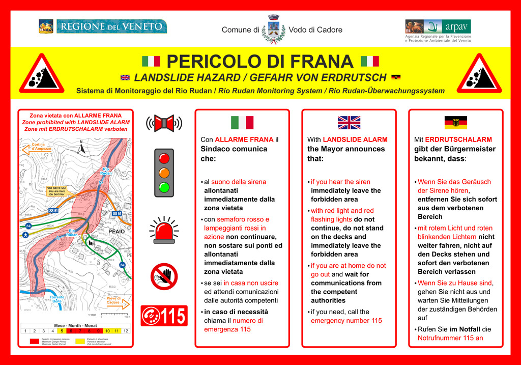
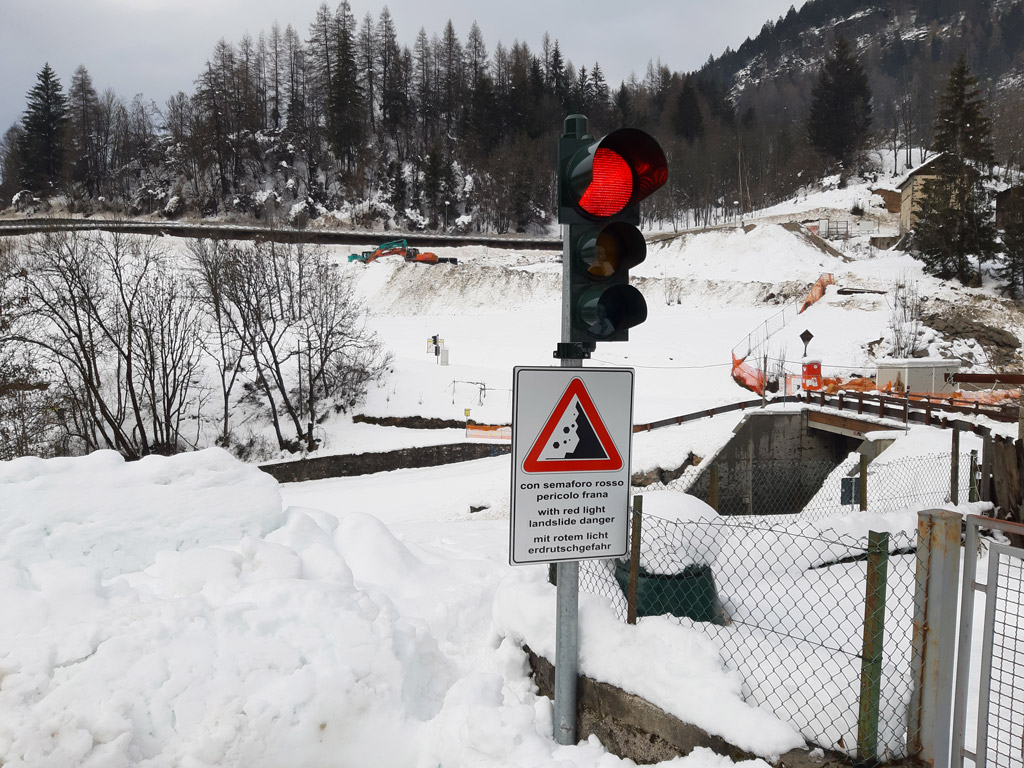
Information panel of the monitoring and alarm system located in the settlement of Peaio and along the communication routes (left) and detail of a traffic light (left – photo by ARPAV)
As part of the project, ARPAV installed 3 monitoring stations along the Rio Rudan in the summer of 2021:
- Station 1: at an approximate altitude of 1450 m a.s.l. where the rio Rudan intersects the mountain path n. 230, equipped with 1 rain gauge and 1 night vision video camera;
- Station 2: at an approximate altitude of 905 m a.s.l. near the dam (upstream of Peaio), equipped with 1 rain gauge and 1 night vision camera;
- Station 3: at an approximate altitude of 890 m a.s.l. on the bridge of the National Road n. 51 “d’Alemagna”, equipped with 2 night vision video cameras.
These sensors want to a) provide further support to the public authorities involved in the management of the Rio Rudan and b) collect data on the debris flows dynamics functional to the development and testing of INADEF alarm system.
- Municipality of Vodo di Cadore: ownership and management of the monitoring and alarm system; dissemination and management of alarms and civil protection actions;
- Veneto Region: construction of hydrogeological defense works and related maintenance; routine maintenance of the monitoring and alarm system; support for civil protection procedures and actions;
- ANAS: manager of the National Road n. 51 “d’Alemagna”;
- ARPAV: designer of the monitoring and alarm system; technical support for weather alerts and system management;
- Local citizens and tourists who live in Peaio or who travel along the communication routes.
A specific emergency civil protection procedure has been in place since May 2020 regarding settlement of Peaio, in relation to the possible debris flows along the Rio Rudan.
The procedure involves the use of weather forecasts and data (rainfall and radar), alert bulletins issued by the Regional Civil Protection, the monitoring and alarm system and on-site monitoring.
The Mayor, as the local civil protection authority, is responsible for the management of civil protection actions and the alarm signal.